Author: admin

  • Risk 1 – Sand Inundation incidents in Liverpool Bay

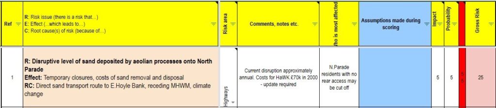
    Offshore sandbanks are never static, their substrate is moved around by tides, and when they are exposed and have time to dry out, by the wind too. Sometimes these forces align to produce very rapid (in geological terms, though sometimes also in human terms) movements. These can be enough to smother coastal towns completely.

    Nearby examples of towns damaged or destroyed by moving sand banks:

    Meols: In the late 15th Century, Meols was continuously inhabited from prehistoric times until the close of the 15th Century. Whilst there are no contemporary descriptions of events that led to the abandonment, there is a thick layer of wind-blown sand that covered habitations and agricultural lands alike. The seat of the de Melas family was relocated to Wallasey due to degradation of the fields and loss of the Manor House. It is believed that an extreme weather event caused an offshore sandbank to move inland with such suddenness that there was little time to retrieve possessions. Consequently, Meols is renowned as one of the richest medieval archeological sites in the country (1,2) Wirral’s own sandy Pompeii!

    There are other less well-described incidents in the medieval period, including Birkdale, Ainsdale, Formby, Crosby, and Hightown (2) 

    Formby: In 1739, Formby suffered a second catastrophic sand inundation which was described in contemporary literature: 

    “In 1690 there was a deep-water channel close to the shore at Formby, with a sandbank outside it which gradually came nearer and nearer. At length, it joined the coast, from which sand commenced to blow, so that in a short time the cultivated ground, gardens, orchards and streets of Formby were entirely covered up.” (3) 

    This necessitated the brick by brick removal, relocation and reconsecration of the Church. Formby was saved from further inundation by the labours of Mr Freshfield who created and planted sandbanks as a barrier to further wind-blown sand, and eventually, the ground lost to sand was reclaimed.

    St Annes 1918-1938: The North Channel of Ribble ran around 200m from the promenade at St Anne. In the late 1800s, the channel started to fill with silt following reduced water flows. By 1910, the channel was no longer navigable and by 1918 it was just a muddy gutter. This gutter filled with wind-blown sand from the Horse Bank, which formed an unbroken sand transport pathway directly to the promenade. By 1930 the beach level at St Annes had risen by 7m. Sand regularly blew over the road, cutting off access and the promenade was unusable. The town council tried to hold back the sand with a sand shield, but this failed after a few years. Costs of clearing up mounted and eventually a decision was made to learn from the fate of Formby. Starr Grass was profusely planted to stabilise the sand collecting against the promenade wall into fixed dunes 4,5

    The situation at Hoylake in 2021 is more or less identical to those at Formby in 1720 and At Annes in 1920. We have lost a channel (the Hoyle Lake,) even its silt is now covered in sand and a large sandbank (the East Hoyle) is moving ashore.

    #risks

    References

    1 Brown, P. J. (2015). Adverse weather conditions in medieval Britain: An archaeological assessment of the 

    impact of meteorological hazards, Masters Thesis, University of Durham  (LINK BROKEN)

    2.Griffiths, D., Philpott, R.A., Egan, G (2007) Meols: The archaeology of the North Wirral coast. Oxford 

    University School of Archaeology: Monograph 68, Institute of Archaeology, University of Oxford 

    3. De Rance, C. E. (1877). The superficial geology of the country adjoining the coasts of southwest 

    Lancashire, comprised in sheet 90, quarter-sheet 91SW, parts of 89NW and SW, 79NE and 91SE of the 1-inch geological survey of England and Wales.Memoirs of the Geological Survey of England and Wales. Longmans, London 

    4. Too much sand 

    5. Where does all this sand come from 

  • Introduction and documents

    Risk Management Plan for Hoylake beach

    A preliminary risk investigation is shown here

    A follow-up document is in preparation which is a risk assessment for returning to the raking previous management regime (without spraying) and doing nothing – i.e. allow the succession processes to continue unhindered and unaided.  It can be found here.

    This document will evolve as the discussion progresses and new information is released.

    The risks currently identified are as follows. There will be posts and discussions on each of these

    Raking specific

    • Council prosecuted for damaging the SSSI/Ramsar site
    • Raking spreads Spartina and removes its competitors

    More significant for raking

    • Disruptive level of sand deposited by aeolian processes onto North Parade 
    • Storm surge, combined with a spring tides causes a high volume overtopping of the promenade
    • Sand acts as a resevoir for enterococci

    Green Beach Specific

    • Some visitors deterred by the lack of groomed beach, presence of vegetation
    • excessive dune build-up causes complaints from residents
    • excessive dune build-up prevents the launch of the lifeboat

    More significant for Green Beach

    • Worries about mosquitos
    • Worries about rats

    The Current Matrix for scoring these risks is shown in the figure. This may change with discussion.

  • Risk 1. Disruptive level of sand deposited by aeolian processes onto North Parade

    Current risk score Raking 25/25, no raking 10/25

    Wind-driven (Aeolian) transport of sand occurs by 3 principal mechanisms: 

    • Suspension in the wind, which accounts for 1% of transportation
    • Saltation, a hopping motion, which accounts for 95% of sand transport
    • Reptation or creep which accounts for approximately 4% of sand transport

    Saltation is the dominant process in locations such as Hoylake. It can start with wind speeds as low as 9mph when sand is dry, and silt-free. Moisture, salt, silt and organic matter increase sand cohesion and so reduce saltation. In contrast, raking reduces sand cohesion and increases saltation. Saltating sand particles “splash” when they impact with the beach. This results in an increase in the number of sand particles that are mobile, with each hop.

    As an illustration, with wind at 20m/s (44mph) that steady state is 6.75m3 of sand per meter per day. If all this sand reached the promenade, the road would be impassable in a few hours (Bagnold, 1941). Whilst force 9 gales are not common, we can expect conditions like this to occur approximately annually.

    Sand will continue to saltate until either:

    • The wind drops or the particles are in the lee of an object
    • The saltating sand meets an area with greater cohesion – eg. moisture or silt
    • The sand meets an obstruction or a gradient which is too steep for the wind strength

    The sand is now dangerously close to overtopping the wall, and when it does the increase in sand problems will be dramatic.

    #risks

    References

    Bagnold, R. A. (1941). The physics of blown sand and desert dunes. Methuen, New York.

  • Why it’s not like Parkgate

    Will Hoylake end up like Parkgate?

    Hoylake and Parkgate are in very different locations. Parkgate is 15km from the mouth of the Dee estuary, whilst Hoylake directly faces Liverpool Bay. This means that Hoylake has conditions of high salinity and extremely high levels of wind-blown sand and very low levels of water carried silt. Parkgate has much fresher conditions and no sand delivery. All the sediment deposited is carried by the river and occasional tides that still flood the area. Parkgate is an estuarine salt marsh. 

    Hoylake has the potential to develop into coastal salt marsh or dunes. The dominant factor that will determine what forms at Hoylake is the relative delivery of wind-blown sand and water deposited silt. As beach levels continue to rise, we can expect Spartina to appear in areas that are still flooded by tides and in receipt of silt. In areas above the mean high water mark, where sand continues to blow in, we can expect Puccinellia, which benefits from being buried in sand (1), and other dune specialists to take over. In contrast, Spartina is killed off by being smothered.(2)

    There are studies underway which should provide a definitive answer, but in lieu of the findings being released, the following points are relevant:-

    • Mean high watermark (MHWM) is retreating at a rate of approximately 20ft a year and the upper beach is now above the astronomical high tide mark(3)
    • The entire stretch from Red Rocks to New Brighton was dunes historically, strongly suggesting that conditions favour dune formation (4-6)
    • Spartina is restricted to the pioneering zone east of Hoyle Rd, around Hilbre point and well off-shore between Kings Gap and Hoyle Rd, closer to shore, above MHWM, it has already been replaced by a wide range of dune specialists which have not been recorded at Hoylake since the late 1800s (7)
    • Conditions at Hoylake mimic those at Birkdale, where dunes are forming rather than Southport where a coastal saltmarsh is forming.
    • Dunes, fixed with Lyme grass have already formed on the western edges of the New Lifeboat station.

    Hoylake cannot end up as an estuarine salt marsh and it is now extremely unlikely that coastal saltmarsh is the destination.

    References

    1. Langlois, E., Bonis, A., & Bouzillé, J. (2001). The Response of Puccinellia maritima to Burial: A Key to Understanding Its Role in Salt-Marsh Dynamics? Journal of Vegetation Science, 12(2), 289-297 https://www.jstor.org/stable/3236613

    2 Hammond, M, 2001, The experimental control of Spartina anglica in estuarine salt marsh http://issg.org/…/ref…/spaang/MarkHammond_PhD_Thesis.pdf

    3. Interim data collected by WBC https://sustainablebeach.org.uk/…/12/PROFILE_EX_02.jpg

    4. Van Keulen’s Map or the Dee, 1715 https://www.dropbox.com/s/daj5pn0v47vj0fc/sandhills.png?dl=0

    5. Photograph showing a dune ridge on Market Street, in approximately the location of the Cottage Hospital https://www.dropbox.com/s/v1c3fi132mc09oe/market%20st.png…

    6. Young, H.E, A Perambulation of the Hundred of Wirral, Henry Young and Sons, Liverpool p196 https://twitter.com/…/status/1407069297168596992/photo/17. Stiles, J. Pers commhttps://twitter.com/joshual951/status/1278783380482654210https://twitter.com/joshual951/status/1310205046794190848

  • It’s Good for Birds

    Won’t grasses growing on the beach affect waders by reducing their feeding areas?

    The effect on wading birds raking/dune and saltmarsh succession at Hoylake Beach – RSPB and CAWOS response

    Currently, waders that feed at Hoylake feed on marine invertebrates that are exposed between tides. Since the green beach is above the intertidal zone, whether it is grassed or raked will not affect the available food supply of intertidal marine macroinvertebrates.. Further east, where the grasses are Spartina not Puccinellia, and tidal inundation still occurs, the argument that a vanishingly small c.0.01% of feeding habitat is covered could be made. However, it is also important to remember that coastal terrestrial invertebrates such as Amphipods and salt-tolerant Diptera within saltmarsh can be superabundant and make up a considerable part of the diet of species such as Curlew, Dunlin, Ringed Plover and Redshank. Providing a mosaic habitat is better in terms of providing greater food heterogeneity. Also, waders need roost sites, just as much as feeding sites. The Green Beach at Southport is an excellent comparison. It vegetated quickly and is still used for feeding, as well now being an important roost site for waders. In short, waders are not losing any habitat; they are gaining habitat.

    In contrast, mechanical raking has been shown to significantly decrease the biomass of macroinvertebrates in multiple studies eg. [Gilburn 2012, Schooler 2019] This can be expected to have a seriously detrimental effect on wading birds using Hoylake if raking is resumed.

    What do WeBS counts show in terms of waders using Hoylake?

    Most arctic wader species are suffering catastrophic declines as a result of climate change affecting their breeding grounds, so any changes need to be viewed in that light. There is a lot of interchange between the Dee, Mersey, Alt, and Ribble Estuaries, and even other sites like the Wash, depending on tides states, exposed intertidal area, weather and localised disturbance. For this reason, WeBS counts are coordinated across the country and the site-specific effects are hard to establish. On the whole waders on the Dee are doing well, because of the mix of habitat mosaic and overall structure. See attached WeBS counts. Taking Hoylake in isolation from the rest of the Estuary, as wind-borne sand as opposed to water-borne silt, continues to be deposited, we can expect to see mudflats replaced with sand flats will alter the relative abundance of different marine invertebrates and we can expect this to have an effect on the balance of species that use Hoylake. Favouring the short-billed surface feeders such as Sanderling which mostly feed on tiny Hydrobia snails [Lourenço 2015], over longer-billed species such as Redshank which specialise in feeding on subsurface invertebrates. The development of a green beach will provide an increase in coastal terrestrial invertebrates.

    Will the ongoing dune succession and green beach have any other benefits for wading birds?

    Initially, the effect will be neutral. Birds use Hoylake beach as a high tide roosting site and their primary concern is to roost and conserve energy. They do use Puccinellia clumps as shelter from strong winds, but as a rule, they just need somewhere to sit undisturbed. Eventually, if the vegetated zone is wide enough, it may put sufficient distance between the roosting birds and potential human disturbance to have a significant benefit. Similarly, we can perhaps expect species such as Ringed Plover to breed on North Wirral once again. There are a few pairs on adjacent coasts [Prater 1988]

    Several other species including Snow Bunting, Reed Bunting, Rock Pipit, Meadow Pipit, Linnet, Brent Goose and White and Yellow Wagtails have been observed feeding in the new habitat at Hoylake. Using the green beach at Southport as a likely predictor of the value to a wide range of species, should the natural accretion process we allowed to continue, it is highly likely that there will be significant benefits to bird populations.

    Graham Jones, RSPB Site Manager, Dee Estuary Nature Reserves. Jane Turner, Cheshire and Wirral Ornithological Society/BTO Surveyor for Hoylake and Meols tetrads.

    References

    British Trust for Ornithology Wetland Bird Survey Online Report

    References

    Gilburn, A Mechanical grooming and beach award status are associated with low strandline biodiversity in Scotland Estuarine Coastal and Shelf Science 107:81–88 https://www.researchgate.net/…/257105673_Mechanical

    Lourenço et al Foraging ecology of sanderlings Calidris alba wintering in estuarine and non-estuarine intertidal areas 2015 Journal of Sea Research, 104 33-40. https://www.researchgate.net/…/279738040_Foraging

    Prater, A.J Ringed Plover Charadrius hiaticula breeding population of the United Kingdom in 1984, Bird Study 36, 154-160 https://www.tandfonline.com/…/10.1080/00063658909477020Schooler, N.K., et al , No lines in the sand: Impacts of intense mechanized maintenance regimes on sandy beach ecosystems span the intertidal zone on urban coasts Ecological Indicators 106 (2019) 105457 https://par.nsf.gov/servlets/purl/10123258#birds

  • Are there any advantages to having vegetation on the beach?

    Sand inundation

    Hoylake has an existing and increasingly severe issue of sand blowing onto the promenade, blocking drains and requiring expensive clean-ups. Just 15 plants per square meter will reduce the volume of blow sand in a gale by 90% and stop it completely below force 7. see graph(1). Consequently, a band of vegetation just a few centimeters high has the potential to dramatically reduce the volume of sand reaching the promenade. See for an analysis of the risks posed by the inshore migration of the East Hoyle Bank.

    This has already avoided what would have been a disruptive delivery of sand in April 2021, when the vegetation caught and held the vast majority of the sand blowing in from the beach after a 3-day spell of strong NNW winds which coincided with a dry beach (2) As sand from each sand blow incident is trapped by the belt of Puccinellia, the height of the foredunes will rise, providing additional protection. In Swansea, an experimental man-made dune gave complete protection from a single sand storm which required a £20,000 clean-up on the unprotected section.

    Storm Surges

    Despite the rising beach levels, there remains a potential for catastrophic damage to the promenade and seafront properties should a storm surge coincide with a spring tide, as occurred in December 2013. Sand dunes have the potential to provide protection against such incidents, and studies in the USA have shown that the presence of dunes dramatically reduced damage to properties compared to adjacent areas where dune formation had been deliberately suppressed(5,6) See also (7)

    References

    1. Aeolian transport over a flat surface by Leo C. van Rijvan Rijn 

    2. People confused as grass ‘disappears’ from beach after storm, Liverpool Echo 2021 

    3. The on-going battle to keep Swansea’s sand on the beach and not on the road

    4. Case Study: Swansea Sand Dunes – Nature-based solution 

    5. Charbonneau, B (2015) A Review of Dunes in Today’s Society, Coastal Management 43 pp 465-470 

    6.Rosenberg, A. 2013. After Destruction of Sandy, Longport Finally Accepting Sand Dunes. The Inquirer. April 12. 

    7. Sand dune processes and management for flood and coastal defence