Does Natural England have enforcement powers or is it only advisory?
To long? Short version is that the law is clear thay are more than just advisory.
There is a claim that natural England is only advisory, The evidence provided for this is is here. https://www.gov.uk/…/organisations/natural-england/about
We are open to any other evidence anyone has to support the case that Natural England is only advisory.
In the mean time we’ve done some digging as our understanding was that Natural England had enforcement powers. Though I have to admit before we went to look I was only basing this on two things.
1: The signs on the prom which explain a bit about the SSSI and that it’s an offence to damage it.
2: The advice that Natural England gave to the council in March 2020 and the later statement they made when the decision to stop raking was challenged by our local councillors. In the statement/advice Natural England said that they could take enforcement action agains the council.
Advice from NE to the council in March 2020 can be found here https://democracy.wirral.gov.uk/…/Natural%20England…
Statement from NE to the council in August 2020 can be found here https://democracy.wirral.gov.uk/…/Natural%20England…
So let us dig deeper because the claim they are only advisory isn’t going away so maybe we have made a mistake.
First the advice document that explains the statutory duty of the council in relation to the SSSI and includes this paragraph:
“Further guidance on public bodies responsibilities for SSSIs can be found from the following webpage: https://www.gov.uk/…/sites-of-special-scientific… “
the link contains, amoungst other sections,
“You could be fined £20,000 in a magistrate’s court or get an unlimited fine in the Crown Court if you:
* do not give Natural England notice of your intention to carry out or approve an activity likely to damage a SSSI
* act before you get Natural England’s response”
“You do not need Natural England’s assent for works that you’ve decided are unlikely to damage a SSSI. You could be prosecuted and fined if you damage a SSSI. Contact Natural England if you’re unsure.”
“You could be prosecuted and made to restore the features of a SSSI if you:
* fail to notify Natural England of the works
* do not take account of Natural England’s advice
* cause more damage than necessary”
and
“If you decide to go ahead without assent
You can still carry out works if:
* Natural England refuses to give its assent
* you believe the conditions attached to an assent are unacceptable You must give Natural England written notice at least 28 working days before the start of the works if you intend to go ahead without assent. You must show that you’ve:
* taken into account any advice Natural England gave you
* considered alternatives that could reduce the impact on the SSSI, such as using lighter vehicles to carry materials
* weighed the balance between conflicting interests, including the special interests of the SSSI Natural England may refer a case to the Secretary of State for Environment, food and rural Affairs if it still has serious concerns about the potential damage to a SSSI. This can lead to a judicial review of the public body’s decision to go aheadwith the works.”
So the council can proceed without assent but it has to have asked for it and it has to notify Natural England and explain why they are going ahead however, they must return the SSSI to its original condition and crucially they are still open to prosecution.
Whilst these documents go some way to explain the situation you really have to look at the law.
Natural England was set up by the Natural Environment and Rural Communities Act 2006 which can be found here https://www.legislation.gov.uk/ukpga/2006/16/contents
You can see there is a section on “Advisory functions” in it it states that Natural England must give advice to public bodies if they request it and that at the request of Natural England, the public authority must inform Natural England in writing whether the advice has been rejected and, if so, why.
But we need to keep reading.
You can see there is also a section on “Other functions” which include Power to bring criminal proceedings.
Further in Part IV Sites of special scientific interest Section 55 is Offences in connection with SSSIs which amends Section 28P of the Wildlife and Countryside Act 1981 so see that for the detail.
The whole act can be found here https://www.legislation.gov.uk/ukpga/1981/69/contents
Section 28P is found here https://www.legislation.gov.uk/ukpga/1981/69/section/28P…
The relevant parts are sections 28P 2 and 3. As the council is a section 28G authority (see section 28G for an explanation).
So it’s an offence if the council don’t comply with Section 28H and is liable on summary conviction, or on conviction on indictment, to a fine.
So it’s clear that Natural England have enforcement powers too.
However, why the confusion over whether the council have to take the advice or not etc?
Well this takes us to Section 28H which is the section the assent is given or withheld under. Let’s take it a by subsections
“(1) A section 28G authority shall give notice to Natural England before carrying out, in the exercise of its functions, operations likely to damage any of the flora, fauna or geological or physiographical features by reason of which a site of special scientific interest is of special interest.”
The council have to notify NE before doing anything that is likely to damage the SSSI “ by reason of which a site of special scientific interest is of special interest” which means it has to be damage to something which is part of the reason the SSSI exists.
You can find the designation of the SSSI details here https://designatedsites.naturalengland.org.uk/SiteDetail.aspx?SiteCode=S1003676&SiteName=wirral&countyCode=&responsiblePerson=&SeaArea=&IFCAArea=
clicking on “citation” takes you to why it was designated an SSSI https://designatedsites.naturalengland.org.uk/…/1003676…
the first section of this is
“Description and Reasons for Notification:
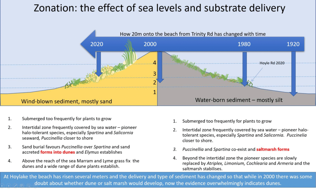
North Wirral Foreshore is located between the outer Dee and Mersey Estuaries. This site is an area of intertidal sand and mudflats and embryonic saltmarsh which is of considerable importance as a feeding and roosting site for passage and wintering flocks of waders, wildfowl, terns and gulls.
The embryonic mixed saltmarsh is formed principally from common saltmarsh-grass Puccinellia maritima and glasswort Salicornia europaea, together with some common cord-grass Spartina anglica.“
There’s more to it but as we’re talking about raking/spraying vegetation we can for now stop there.
So anything which may damage the embryonic mixed salt marsh needs to be notified to Natural England or the council are liable on summary conviction, or on conviction on indictment, to a fine.
There is also a list of operations which may damage the SSSI https://designatedsites.naturalengland.org.uk/…/1003676… this covers things like spraying herbicides/rotovating/ploughing/cutting etc amongst other things.
The council had done this when asking for assent and for changes to the assent in 2010 and 2015. The Natural England response is covered in subsection 3.
“(3) In response to the notice referred to in subsection (1), Natural England may send a notice—
(a) saying that they do not assent to the proposed operations, or
(b) assenting to them (with or without conditions),
but if they do not send a notice under paragraph (b) within the period of 28 days beginning with the date of the notice under subsection (1) they shall be treated as having declined to assent.”
So previously the council had got the assent for some activity though this ran out in March 2021 and the natural England advice was
“Due to the presence of other species it is now difficult to undertake spraying and raking in a way that is legally compliant with the Assent; non-compliance with the Assent poses risks of enforcement by Natural England.“
So where are we now?
Well the council have no assent and would have to notify the council before they did anything which might damage the salt marsh, specifically the saltmarsh-grass Puccinellia maritima and glasswort Salicornia europaea (known as samphire) and Spartina anglica.
Then Natural England have to reply as per subsection 3 above within 28 days or they are deemed to have declined to give assent.
So what happens if Natural don’t give assent?
If you check the Natural England advice/statements at the top you’ll see Natural England said they are unlikely to give assent for raking the whole beach but that
“ Vegetation control across the whole coast would not be acceptable as this is likely to be contrary to the site’s conservation objectives, it is also unlikely to be economic or sustainable. Smaller areas of vegetation control may have scope to be consented but there should be clear justifications for requests to control vegetation establishment.”
also
“ There needs to be a thorough ecological survey of any areas to be proposed for targeting of vegetation control. “
So if the council don’t do what they are currently doing (surveys) then they are unlikely to get assent.
But what happens if the council acts without assent?
Well we’ve seen from subsection 1 above they have to notify Natural England or they are liable on summary conviction, or on conviction on indictment, to a fine. If Natural England don’t give it we drop into subsection 4.
“(4) If Natural England do not assent, or if the authority proposes to carry out the operations otherwise than in accordance with the terms of the Council’s assent, the authority—
(a) shall not carry out the operations unless the condition set out in subsection (5) is satisfied, and
(b) shall comply with the requirements set out in subsection (6) when carrying them out.”
So if the council are either going to act without the consent or they are going to do something agains the conditions of the assent then they need to comply with subsections 5 AND 6.
“(5) The condition is that the authority has, after the expiry of the period of 28 days beginning with the date of the notice under subsection (1), notified Natural England of (note a typo here in the website) —
(a) the date on which it proposes to start the operations (which must be after the expiry of the period of 28 days beginning with the date of the notification under this paragraph), and
(b) how (if at all) it has taken account of any written advice it received from Natural England, before the date of the notification under this paragraph, in response to the notice under subsection (1).”
This is the council must notify Natural England of their intention to proceed without assent which must be at least 28 days later and it must state how if at all it considered the assent/conditions/advice.
AND subsection 6
“(6) The requirements are-
(a) that the authority carry out the operations in such a way as to give rise to as little damage as is reasonably practicable in all the circumstances to the flora, fauna or geological or physiographical features by reason of which the site is of special interest (taking account, in particular, of any such advice as is referred to in subsection (5)(b)); and
(b) that the authority restore the site to its former condition, so far as is reasonably practicable, if any such damage does occur.”
So when then doing whatever the council decide to do without assent, they must do it in a way to minimise any damage and to restore the damage.
In short if the actions the council do damage the SSSI, as above this includes damaging Spartina/puccinella etc, then they must re-instate it afterwards. eg if you take away the spartina you must then put it back.
If not the council are liable on summary conviction, or on conviction on indictment, to a fine.
So they can ignore the assent but they can’t damage the SSSI without restoring it or they may face enforcement action.
Sorry this is a long detailed post but it’s more nuanced than Natural England is advisory or not. Naturaal England has a duty to advise and it’s possible to ignore the advice so long as you don’t damage the SSSI or re-instate it after you’ve done whatever you are planning on doing, if you fall foul then they can use their enforcement powers.
It’s a bit like saying a police officer can’t physically prevent you speeding but ignoring that if you do they can fine you.
