Category: Guide 1

  • Wind direction and dune formation

    What is the relationship between prevailing wind direction and dune formation?

    Dunes will never form at Hoylake because the prevailing wind direction is WSW something I’m hearing a lot. The source of this seems to originate from a Ward councillor and it gets repeated frequently in much the same way as Hoylake will end up like Parkgate, that only makes sense if you fail to apply critical thinking.

    I realise that in-depth science explanations can be hard to wade through – so here is the  TLDR The conditions for dune formation are as perfect as its possible to be at Hoylake. If you don’t fancy the science, skip to the photos at the end with these three questions in your head:

    • (i) Is there evidence that the conditions at Hoylake previously, produced dunes
    • (ii) How does the relationship between the shore orientation and prevailing wind direction at Hoylake compare to other locations with dunes
    • (iii) Do we have more or less exposed sand than other locations that are dune building.

    HERE COMES THE SCIENCY BIT

    96% of sand movement is by saltation, 1% by suspension and 3% by reptation (creep) If you don’t know about saltation yet – look here 

    There are 3 misconceptions that need correcting – two in the linked image and the 3rd on a recent thread. 

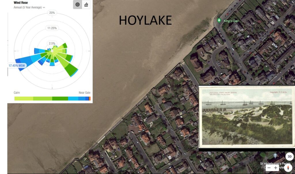
    (i) The prevailing wind direction at Hoylake isn’t SW, its WSW and as you will see below, that’s really important

    (ii) The wind needs to be perpendicular to the shore – ie NW at Hoylake for dunes to form. In reality, any onshore wind, even 1 degree from parallel is all you need to form dunes. That 178 degrees out of the wind rose building dunes. What isn’t immediately obvious is that the most effective wind direction for dune building is just onshore. This is because in addition to wind strong enough to get sand moving, you also need to have a long enough path of dry sand to set up saltation – this length varies with wind strength, but it’s around about 100m usually. Because the outer beach is more frequently covered by tides, conditions for establishing saltation are more frequent close to shore, so just onshore winds are the best dune builders, blowing along the dry upper beach, building up a cloud of mobile sand ready to drop on the embryo dunes.

    (iii) The last misconception is that all wind directions are equal when it comes to moving sand. If you recall saltation moves 2 orders of magnitude more than suspension. An offshore wind doesn’t cross 100m of open dry sand in order to set up saltation. Dune grass roots stop reptation, so it’s just suspension that can take sand back out. Of course, further out on the beach saltation can set up. This is why locations with prevailing offshore winds can form dunes – just so it’s clear – less frequent saltating conditions deposit so much more sand than more frequent offshore conditions can remove it. It’s also why beaches with dune backing have a tendency to steepen, something that is measurably happening at Hoylake. The beach line is moving offshore as the sea is moving onshore and eventually, Hoylake might become a swimming location (as opposed to its historical position as a “wallowing” in the gutter location)

    ORIENTATION OF SELECTED NW BEACHES 

    • Hoylake. The Beach faces nearly exactly NW, the prevailing wind is WSW – the ideal direction for saltation.
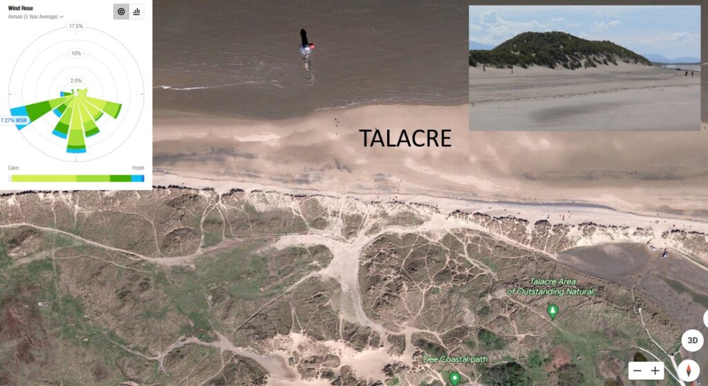
    • Talacre. The beach faces a little E of North and the prevailing wind is WSW – ie offshore. This of course hasn’t stopped impressive dunes from forming. This as you now know is because though onshore winds are rarer, the amount of sand they deposit is orders of magnitude larger.
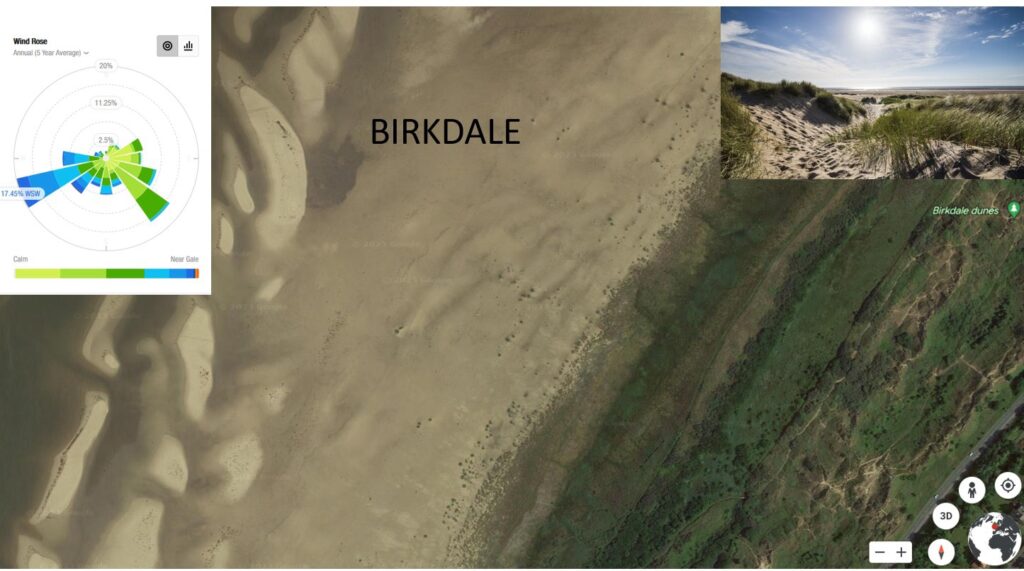
    • Birkdale. The orientation is NW – almost identical to Hoylake, and unsurprisingly the prevailing wind is WSW, though there is much less exposed sand. Birkdale is the most apt comparison to Hoylake, not least since it’s 10 years ahead of us in the recovery from mechanical (not sure about chemical) suppression of succession vegetation.
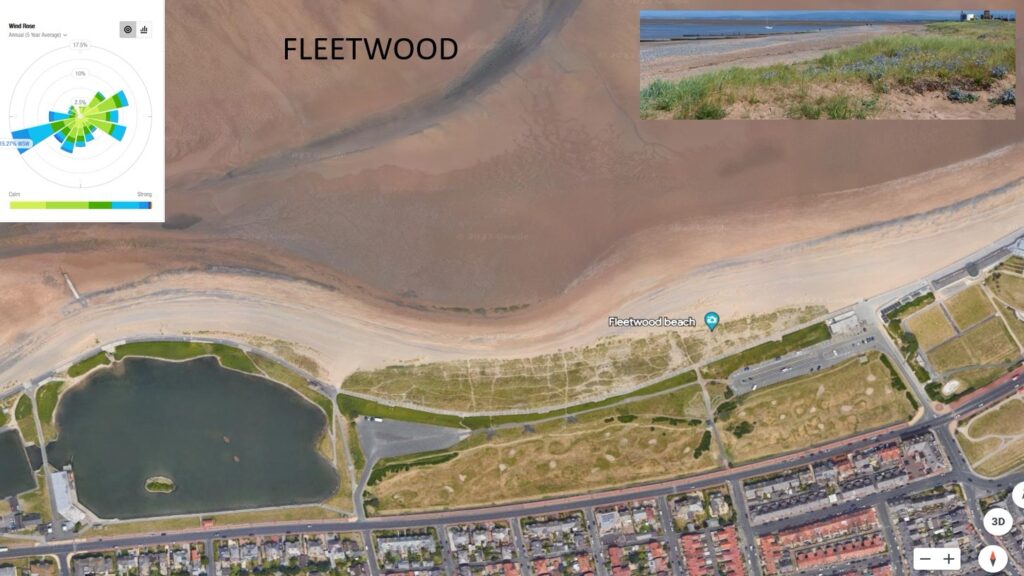
    • Fleetwood. Fleetwood faces a few degree west of north, and so the prevailing WSW wind is offshore and despite there being not very much exposed sand, a lovely low dune system is forming outside the concrete sea wall.
  • Groundwater v Drains

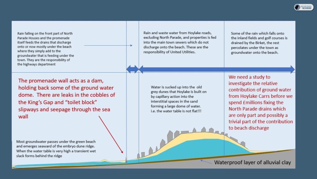
    Groundwater v Drains – study needed

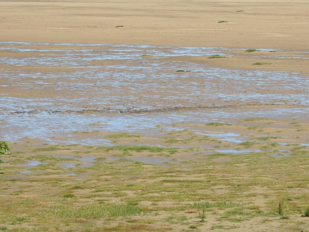
    I had another opportunity to study the water table – following heavy rain a couple of nights ago, there was an initial flow of water from the North Parade drains. This water immediately sunk through the beach. A couple of days later groundwater is showing past the embryo dune ridge.

    I think it’s quite probable that this is another unintended consequence of our ancestors thinking they were doing something useful by draining the carrs behind Hoylake and Meols, but actually they were just saving up problems for the future. Willow is amazingly good at taking groundwater and putting it into the atmosphere by a process called evapotranspiration. 

    Before WBC spend any money fixing our Victorian drains (a multi-million-pound operation) I’d be quite keen to see if there is:-

    (i) any point in doing this

    (ii) if it was possible to come up with a more environmentally friendly solution.

    I think it’s probably worthy of a whole new FB group because there are so many other possible benefits to reviving the idea of establishing a Wildfowl and Wetlands Centre on the Carrs, which at its most ambitions could be a flood abatement scheme for north Wirral, a water treatment option for Hoylake, Meols and parts of West Kirby. And that’s before we get to Beavers and Otters.

    But for now I’ll park it here.

    • A visitor attraction [Burton Mere RSPB attracts 40,000 visitors a year, Washington WWT 83,817, Martin Mere WWT 170,000 Leighton Moss RSPB 100,000 etc]
    • Sustainable water treatment. Eg 1 hectare of Phragmites reed-bed, removes the need to discharge at sea and offers an alternative discharge point to the drains currently discharging onto Hoylake beach [Masi]
    • Reduce flooding in the lower Birket valley through capture, slower release and evapotranspiration of flood and groundwater in the upper Birket [ Marc, Tariq]
    • Reduce groundwater discharge onto the beach at Hoylake by lowering the water table [figure 4]
    • Carbon Net-Zero target – one reed bed system has been shown to reduce CO2 equivalent by 70 tons a year compared to conventional methods[Edie] . The Carbon sequestration rate of woodland is approximately 70t of CO2 equivalent per hectare per year [Gregg et al 2021]
    • Biofuel generation via short rotation coppicing is estimated at 46 MW per hectare per anum a 99.6% in CO2 equivalent reduction per GJ over fossil fuels [Forest Research]
    • Biodiversity gain. Wet Woodland, Reedbeds and Coastal and Floodplain Grazing Marsh are all high priority Biodiversity action plan habitats [JNCC]
    • A research and education facility

    REFERENCES

    van Bussel 2006, The potential contribution of a short-rotation willow plantation to mitigate climate change

    Edie 2020 Ground-breaking reed bed system cuts carbon for Essex & Suffolk Water

    Gregg et al 2021 Carbon storage and sequestration by habitat: a review of the evidence

    Harding 2007The Wirral Carrs and Holms JOURNAL OF THE ENGLISH PLACE-NAME SOCIETY 39 45-57

    Hoylake Village Life 2017 Proposals for a Hoylake Eco-Golf Resort Wildfowl and Wetlands Centre

    Forest Research Potential yields of Biofuels per hectare per annum

    JNCC 2016 List of Biodiversity Action Plan priority habitiats

    Marc, V.; Robinson, M. The long‐term water balance (1972–2004) of upland forestry and grassland at Plynlimon, mid‐Wales. Hydrol. Earth Syst. Sci. 2007, 11, 44–60, doi:10.5194/hess‐11‐44‐2007

    Masi et al 2017Large scale application of French reed beds: Municipal wastewater treatment for a 20,000 inhabitant’s town in Moldova Water Science & Technology 76, 134-146

    Tariq et al 2020 Applied Sciences 10(23):8752 A Critical Review of Flood Risk Management and the Selection of Suitable Measures

  • Time-lapse of accretion 

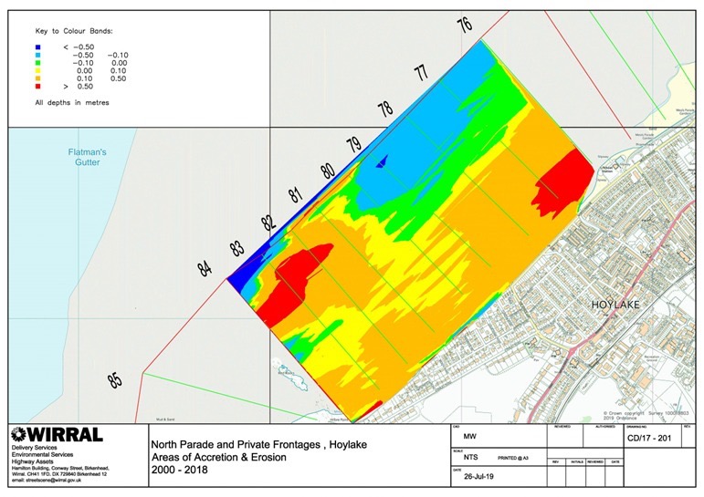
    This is where I’ve been all week. We’ve split the beach into 360 squares and monitored the levels in each square over time. Using this we’ve been able to generate equations which predict beach height in any year at each location. This means that we can fill in the missing years and missing measurements) The modelled results have an M in the top left corner. This wouldn’t be possible (in less than a month), without the help of Elina Thomassonand her astounding ability to code. At one point today I had over 70 spreadsheets open. Now we can generate a map or a prediction in a few minutes. The models are a lot smoother than the real data – they don’t have the local fluctuations in levels that the raw data has

    Aside from the smoothness, they are hard to tell from the raw data and the significant features are all recorded correctly.

    Enjoy – this was a labour of love!

    Use pause if it goes too fast for you!

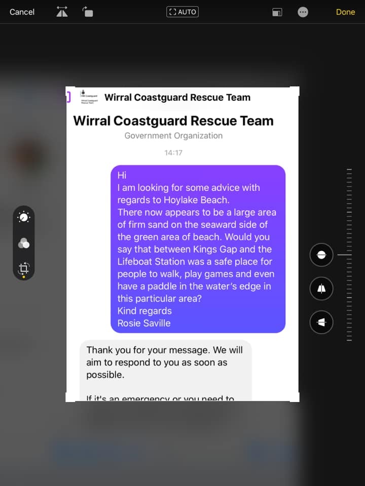
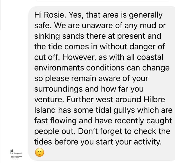
  • Is the beach safe beyond the grass [Kings Gap to the Lifeboat Station]

    Is it safe to go out on the beach beyond the grass.

    Some people have suggested that it is dangerous to venture out onto Hoylake beach. 

    The advice from the coastguards is that there are no specific dangers, 

  • Is leaving the beach to nature attracting more Rats?

    A freedom of information act was requested from the beginning of 2017 (prior to Wirral Borough Council (WBC) stopping herbicide treatment on the beach), and different areas of the Wirral were ranked based on the number of call outs for WBC rat control service.

    West Kirby was ranked top with 32 call outs, whereas Hoylake was ranked 22nd with 10. Neston and Parkgate are not part of WBC, but the closest area to Parkgate on the list, Gayton, had just five call outs (Liverpool Echo, 2018).

    Confounding factors may include the size of gardens, being aware of pest control council services and being able to afford them. A study by Lambert et al (2017) identified the following risk factors for rats and mice reported on or near dwellings ‘including litter around the dwelling, pets and/or livestock in the garden, drainage faults, housing density, the urban-rural nature of the area and tenure type’. In addition, the data do not include private pest control companies, but does provide a comparison of Council treatment service requests across the area. 

    Rats are predominantly found in densely human populated areas where they can gain easy access to food (Frei, 2019 and Tamayo-uria et al, 2014). Older houses, more densely populated houses, and houses closer to vegetated areas, markets and cat feeding stations had higher risks of rat infestations (Tamayo-uria et al, 2014).

    In addition to built up areas, rats can also be found along river beds, near areas of human agriculture, and other areas such as near trees (Traweger et al, 2006 and Modlinska and Pisula, 2020). However, when examining trapping success of rats within different soil types, rats were found less often in sand compared to other soil types and when running, standing, or no water sites were compared, fewer rats were trapped in standing water sites (Traweger et al, 2006). Rats can build extensive tunnel networks (Modlinska and Pisula, 2020), therefore making sand a less suitable environment to build tunnels in. 

    Factors which limit Rat movement include having to cross roads, waterways, and areas which are resource poor (Byers et al, 2019). Rats have recently been spotted on New Brighton beach, demonstrating that they can be found in a beach environment, however this is thought to be related to litter on the beach (Liverpool Echo, 2021). Rats are omnivores and will eat a variety of food including nuts, wheat, meat, cheese, chocolate and are often attracted to human rubbish, compost and bird feeding areas (Jackson, 2016; Barnett, 1956; BPCA, 2021 and Modlinska and Pisula, 2020). Milk chocolate, walnuts, Nutella and cheese have been identified as some of the most successful foods to attract rats into traps (Jackson, 2016).

    Rats can be reservoirs of zoonotic diseases (diseases which can pass from animals to humans), and can also cause damage to houses, such as biting through electrical cables and insulation (BPCA, 2021). Therefore the risks of attracting rats into the home need to be considered. 

    In conclusion, rats can pose a problem to homes, although measures can be taken to reduce the risk of attracting rats, such as using compost containers which can’t be accessed by rats, keeping rubbish in containers, and making sure any bird feed is not accessible from the ground. There are limited data on the prevalence of rats found on beaches, although when they have been recorded in these environments, they usually coincide with the presence of litter, and rats are less inclined to cross roads than other animals. What’s more, rats often live in extensive tunnel systems, which makes a sand/beach environment less preferable for a living space. This suggests that human homes are still the most preferred environment for rats compared to a beach environment, especially one which is separated from homes by a road. 

    It is unknown how rats may interact with the beach environment in the future, so this needs to be continually monitored, especially if litter increases. There is also a lack of current data on the current numbers of rats in Hoylake and on the beach, so further research is needed. 

    References

    Liverpool Echo (2018) Wirral’s rat capitals ranked – and the result is a big surprise. Accessed 12th August 2021, available at https://www.liverpoolecho.co.uk/news/liverpool-news/wirrals-rat-capitals-ranked-result-15045663

    Lambert, M., Vial, F., Pietravalle, S. and Cowan, D., (2017). Results of a 15-year systematic survey of commensal rodents in English dwellings. Scientific reports, 7(1), pp.1-12. Available at https://www.nature.com/articles/s41598-017-15723-9 

    Lukas Frei (2019) Rat City: Visualizing New York City’s Rat Problem. Accessed 12th August 2021. Available at https://towardsdatascience.com/rat-city-visualizing-new-york-citys-rat-problem-f7aabd6900b2 

    Tamayo-Uria, I., Mateu, J., Escobar, F. and Mughini-Gras, L., (2014). Risk factors and spatial distribution of urban rat infestations. Journal of Pest Science, 87(1), pp.107-115. Available at https://www.researchgate.net/publication/260528748_Risk_factors_and_spatial_distribution_of_urban_rat_infestations 

    Traweger, D., Travnitzky, R., Moser, C., Walzer, C. and Bernatzky, G., (2006). Habitat preferences and distribution of the brown rat (Rattus norvegicus Berk.) in the city of Salzburg (Austria): implications for an urban rat management. Journal of Pest Science, 79(3), pp.113-125. Available at https://www.researchgate.net/publication/225479841_Habitat_preferences_and_distribution_of_the_brown_rat_Rattus_norvegicus_Berk_in_the_city_of_Salzburg_Austria_Implications_for_an_urban_rat_management

    Modlinska, K. and Pisula, W., 2020. The natural history of model organisms: The Norway rat, from an obnoxious pest to a laboratory pet. Elife, 9, p.e50651. Available at https://elifesciences.org/articles/50651 

    Byers, K.A., Lee, M.J., Patrick, D.M. and Himsworth, C.G., (2019). Rats about town: a systematic review of rat movement in urban ecosystems. Frontiers in Ecology and Evolution, 7, p.13. Available at https://www.frontiersin.org/articles/10.3389/fevo.2019.00013/full 

    Liverpool Echo (2021) ‘Boy terrified to go back to beach where rats ‘were coming onto the sand’. Accessed 14th August 2021, available at https://www.liverpoolecho.co.uk/news/liverpool-news/boy-terrified-go-back-beach-21307337 

    Jackson, M., Hartley, S. and Linklater, W., 2016. Better food-based baits and lures for invasive rats Rattus spp. and the brushtail possum Trichosurus vulpecula: a bioassay on wild, free-ranging animals. Journal of Pest Science, 89(2), pp.479-488. Available at http://explore.bl.uk/primo_library/libweb/action/display.do?tabs=detailsTab&gathStatTab=true&ct=display&fn=search&doc=ETOCRN377600834&indx=1&recIds=ETOCRN377600834 

    Barnett, S.A., 1956. Behaviour components in the feeding of wild and laboratory rats. Behaviour, 9(1), pp.24-43. Available at https://brill.com/view/journals/beh/9/1/article-p24_2.xml 

    British Pest Control Association (BPCA) (2021) ‘Pest advice for controlling Brown Rats’. Accessed 15th August 2021. Available at https://bpca.org.uk/a-z-of-pest-advice/brown-rat-control-how-to-get-rid-of-brown-rats-bpca-a-z-of-pests/189176

  • What new plants have been discovered on Hoylake Beach?

    NB. This will develop with time!

    Sea Rocket Cakile maritima 11th August 2021 , photgraphed by Maureen Hansonen Hanson 

    Sea Spurrey (presumed Lesser Spergularia marina) Taken by Kate Rice near Kings Gap on July 10th 2021 

    Glasswort sp Salicornis sp Taken by Kate Rice in June 2921 

    Rock Samphire Crithmum maritimum 10th August 2021 by Laura Higginbottom 

    Sea Mayweed Tripleurospermum maritimum 10th August 2021 by 

  • Why it’s not like Parkgate

    Will Hoylake end up like Parkgate?

    Hoylake and Parkgate are in very different locations. Parkgate is 15km from the mouth of the Dee estuary, whilst Hoylake directly faces Liverpool Bay. This means that Hoylake has conditions of high salinity and extremely high levels of wind-blown sand and very low levels of water carried silt. Parkgate has much fresher conditions and no sand delivery. All the sediment deposited is carried by the river and occasional tides that still flood the area. Parkgate is an estuarine salt marsh. 

    Hoylake has the potential to develop into coastal salt marsh or dunes. The dominant factor that will determine what forms at Hoylake is the relative delivery of wind-blown sand and water deposited silt. As beach levels continue to rise, we can expect Spartina to appear in areas that are still flooded by tides and in receipt of silt. In areas above the mean high water mark, where sand continues to blow in, we can expect Puccinellia, which benefits from being buried in sand (1), and other dune specialists to take over. In contrast, Spartina is killed off by being smothered.(2)

    There are studies underway which should provide a definitive answer, but in lieu of the findings being released, the following points are relevant:-

    • Mean high watermark (MHWM) is retreating at a rate of approximately 20ft a year and the upper beach is now above the astronomical high tide mark(3)
    • The entire stretch from Red Rocks to New Brighton was dunes historically, strongly suggesting that conditions favour dune formation (4-6)
    • Spartina is restricted to the pioneering zone east of Hoyle Rd, around Hilbre point and well off-shore between Kings Gap and Hoyle Rd, closer to shore, above MHWM, it has already been replaced by a wide range of dune specialists which have not been recorded at Hoylake since the late 1800s (7)
    • Conditions at Hoylake mimic those at Birkdale, where dunes are forming rather than Southport where a coastal saltmarsh is forming.
    • Dunes, fixed with Lyme grass have already formed on the western edges of the New Lifeboat station.

    Hoylake cannot end up as an estuarine salt marsh and it is now extremely unlikely that coastal saltmarsh is the destination.

    References

    1. Langlois, E., Bonis, A., & Bouzillé, J. (2001). The Response of Puccinellia maritima to Burial: A Key to Understanding Its Role in Salt-Marsh Dynamics? Journal of Vegetation Science, 12(2), 289-297 https://www.jstor.org/stable/3236613

    2 Hammond, M, 2001, The experimental control of Spartina anglica in estuarine salt marsh http://issg.org/…/ref…/spaang/MarkHammond_PhD_Thesis.pdf

    3. Interim data collected by WBC https://sustainablebeach.org.uk/…/12/PROFILE_EX_02.jpg

    4. Van Keulen’s Map or the Dee, 1715 https://www.dropbox.com/s/daj5pn0v47vj0fc/sandhills.png?dl=0

    5. Photograph showing a dune ridge on Market Street, in approximately the location of the Cottage Hospital https://www.dropbox.com/s/v1c3fi132mc09oe/market%20st.png…

    6. Young, H.E, A Perambulation of the Hundred of Wirral, Henry Young and Sons, Liverpool p196 https://twitter.com/…/status/1407069297168596992/photo/17. Stiles, J. Pers commhttps://twitter.com/joshual951/status/1278783380482654210https://twitter.com/joshual951/status/1310205046794190848

  • It’s Good for Birds

    Won’t grasses growing on the beach affect waders by reducing their feeding areas?

    The effect on wading birds raking/dune and saltmarsh succession at Hoylake Beach – RSPB and CAWOS response

    Currently, waders that feed at Hoylake feed on marine invertebrates that are exposed between tides. Since the green beach is above the intertidal zone, whether it is grassed or raked will not affect the available food supply of intertidal marine macroinvertebrates.. Further east, where the grasses are Spartina not Puccinellia, and tidal inundation still occurs, the argument that a vanishingly small c.0.01% of feeding habitat is covered could be made. However, it is also important to remember that coastal terrestrial invertebrates such as Amphipods and salt-tolerant Diptera within saltmarsh can be superabundant and make up a considerable part of the diet of species such as Curlew, Dunlin, Ringed Plover and Redshank. Providing a mosaic habitat is better in terms of providing greater food heterogeneity. Also, waders need roost sites, just as much as feeding sites. The Green Beach at Southport is an excellent comparison. It vegetated quickly and is still used for feeding, as well now being an important roost site for waders. In short, waders are not losing any habitat; they are gaining habitat.

    In contrast, mechanical raking has been shown to significantly decrease the biomass of macroinvertebrates in multiple studies eg. [Gilburn 2012, Schooler 2019] This can be expected to have a seriously detrimental effect on wading birds using Hoylake if raking is resumed.

    What do WeBS counts show in terms of waders using Hoylake?

    Most arctic wader species are suffering catastrophic declines as a result of climate change affecting their breeding grounds, so any changes need to be viewed in that light. There is a lot of interchange between the Dee, Mersey, Alt, and Ribble Estuaries, and even other sites like the Wash, depending on tides states, exposed intertidal area, weather and localised disturbance. For this reason, WeBS counts are coordinated across the country and the site-specific effects are hard to establish. On the whole waders on the Dee are doing well, because of the mix of habitat mosaic and overall structure. See attached WeBS counts. Taking Hoylake in isolation from the rest of the Estuary, as wind-borne sand as opposed to water-borne silt, continues to be deposited, we can expect to see mudflats replaced with sand flats will alter the relative abundance of different marine invertebrates and we can expect this to have an effect on the balance of species that use Hoylake. Favouring the short-billed surface feeders such as Sanderling which mostly feed on tiny Hydrobia snails [Lourenço 2015], over longer-billed species such as Redshank which specialise in feeding on subsurface invertebrates. The development of a green beach will provide an increase in coastal terrestrial invertebrates.

    Will the ongoing dune succession and green beach have any other benefits for wading birds?

    Initially, the effect will be neutral. Birds use Hoylake beach as a high tide roosting site and their primary concern is to roost and conserve energy. They do use Puccinellia clumps as shelter from strong winds, but as a rule, they just need somewhere to sit undisturbed. Eventually, if the vegetated zone is wide enough, it may put sufficient distance between the roosting birds and potential human disturbance to have a significant benefit. Similarly, we can perhaps expect species such as Ringed Plover to breed on North Wirral once again. There are a few pairs on adjacent coasts [Prater 1988]

    Several other species including Snow Bunting, Reed Bunting, Rock Pipit, Meadow Pipit, Linnet, Brent Goose and White and Yellow Wagtails have been observed feeding in the new habitat at Hoylake. Using the green beach at Southport as a likely predictor of the value to a wide range of species, should the natural accretion process we allowed to continue, it is highly likely that there will be significant benefits to bird populations.

    Graham Jones, RSPB Site Manager, Dee Estuary Nature Reserves. Jane Turner, Cheshire and Wirral Ornithological Society/BTO Surveyor for Hoylake and Meols tetrads.

    References

    British Trust for Ornithology Wetland Bird Survey Online Report

    References

    Gilburn, A Mechanical grooming and beach award status are associated with low strandline biodiversity in Scotland Estuarine Coastal and Shelf Science 107:81–88 https://www.researchgate.net/…/257105673_Mechanical

    Lourenço et al Foraging ecology of sanderlings Calidris alba wintering in estuarine and non-estuarine intertidal areas 2015 Journal of Sea Research, 104 33-40. https://www.researchgate.net/…/279738040_Foraging

    Prater, A.J Ringed Plover Charadrius hiaticula breeding population of the United Kingdom in 1984, Bird Study 36, 154-160 https://www.tandfonline.com/…/10.1080/00063658909477020Schooler, N.K., et al , No lines in the sand: Impacts of intense mechanized maintenance regimes on sandy beach ecosystems span the intertidal zone on urban coasts Ecological Indicators 106 (2019) 105457 https://par.nsf.gov/servlets/purl/10123258#birds

  • Are there any advantages to having vegetation on the beach?

    Sand inundation

    Hoylake has an existing and increasingly severe issue of sand blowing onto the promenade, blocking drains and requiring expensive clean-ups. Just 15 plants per square meter will reduce the volume of blow sand in a gale by 90% and stop it completely below force 7. see graph(1). Consequently, a band of vegetation just a few centimeters high has the potential to dramatically reduce the volume of sand reaching the promenade. See for an analysis of the risks posed by the inshore migration of the East Hoyle Bank.

    This has already avoided what would have been a disruptive delivery of sand in April 2021, when the vegetation caught and held the vast majority of the sand blowing in from the beach after a 3-day spell of strong NNW winds which coincided with a dry beach (2) As sand from each sand blow incident is trapped by the belt of Puccinellia, the height of the foredunes will rise, providing additional protection. In Swansea, an experimental man-made dune gave complete protection from a single sand storm which required a £20,000 clean-up on the unprotected section.

    Storm Surges

    Despite the rising beach levels, there remains a potential for catastrophic damage to the promenade and seafront properties should a storm surge coincide with a spring tide, as occurred in December 2013. Sand dunes have the potential to provide protection against such incidents, and studies in the USA have shown that the presence of dunes dramatically reduced damage to properties compared to adjacent areas where dune formation had been deliberately suppressed(5,6) See also (7)

    References

    1. Aeolian transport over a flat surface by Leo C. van Rijvan Rijn 

    2. People confused as grass ‘disappears’ from beach after storm, Liverpool Echo 2021 

    3. The on-going battle to keep Swansea’s sand on the beach and not on the road

    4. Case Study: Swansea Sand Dunes – Nature-based solution 

    5. Charbonneau, B (2015) A Review of Dunes in Today’s Society, Coastal Management 43 pp 465-470 

    6.Rosenberg, A. 2013. After Destruction of Sandy, Longport Finally Accepting Sand Dunes. The Inquirer. April 12. 

    7. Sand dune processes and management for flood and coastal defence